Calgary Real Estate Maps | MLS® Zone Maps & Communities

Calgary Real Estate Maps

Search Calgary real estate maps, MLS® community zone maps, new community maps and property listings updated every 10 minutes all Calgary Communities, housing market trends.

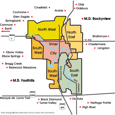
Interactive Calgary MLS® Zone Map

Click any zone to explore communities and listings new in that area:

Calgary real estate maps showing MLS zones NW, NE, SW, SE and Inner City

Search Calgary Real Estate by Community

Explore detailed listings for each Calgary community with our comprehensive search tools:

Northwest Calgary Real Estate

Explore NW Calgary communities including Tuscany, Scenic Acres, and Dalhousie. This area offers mountain views and family-friendly neighborhoods.

Average Home Price: $550,000

Northeast Calgary Real Estate

Discover NE Calgary communities like Taradale, Coral Springs, and Marlborough. Known for affordability and cultural diversity.

Average Home Price: $420,000

Southwest Calgary Real Estate

SW Calgary features upscale communities like Aspen Woods, Springbank Hill, and Glenmore Park with proximity to downtown.

Average Home Price: $750,000

Southeast Calgary Real Estate

SE Calgary includes McKenzie Towne, Auburn Bay, and Cranston with newer developments and lake communities.

Average Home Price: $480,000

Inner City/Downtown Calgary

Downtown Calgary and surrounding inner city communities offer condos, townhomes, and character homes with urban convenience.

Average Home Price: $600,000

Frequently Asked Questions About Calgary Real Estate Maps

Explore official City of Calgary tools and resources for property research.

Calgary is divided into five main MLS® zones: Northwest (NW), Northeast (NE), Southwest (SW), Southeast (SE), and the Inner City/Downtown area. Each zone has distinct characteristics, property types, and price ranges. In 2016, CREB® refined these into eight districts for more precise market data: City Centre, North, Northeast, East, Southeast, South, West, and Northwest [citation:9][citation:10].

The City of Calgary offers several powerful tools:
  • Development Map (DMap): View development permit applications, land use redesignations, and 3D renderings of proposed projects [citation:1][citation:4].
  • My Property 3.0: Access legal and zoning details, permit history, year of construction, and community census data [citation:1][citation:3].
  • City Online Property Products: Purchase detailed reports including Assessment Details, Building Permits Status, and MapView Reports [citation:3].

The City of Calgary provides official flood maps to identify flood-prone areas. Start with the Government of Alberta Flood Hazard Map [citation:13]. The City's Regulatory Flood Map shows Floodway, Flood Fringe, and Overland Flow areas on the Bow River, Elbow River, Nose Creek, and West Nose Creek [citation:13][citation:15]. In November 2025, updated Flood Hazard Area maps were released with a new four-category approach to flood risk [citation:14][citation:15].

Yes, we provide specialized maps showing Calgary school catchment areas. You can filter properties based on specific school zones to find homes in your desired educational districts. For official school boundaries, refer to the Calgary Board of Education and Calgary Catholic School District websites.

Calgary is divided into 14 wards, each represented by an elected city councillor. Use the official City of Calgary Ward Finder to enter your address and identify your ward and councillor [citation:8]. Ward boundaries were last updated following the 2021 ward boundary review [citation:8].

The Calgary Development Map is an interactive tool that shows development permit applications and land use redesignations across the city [citation:1][citation:4]. You can search by address, permit number, or community to view active and past applications. It also includes 3D renderings and shadow studies to visualize how proposed developments will affect sunlight, views, and ambiance [citation:1].

My Property 3.0 is a self-serve tool that provides detailed information on any property in Calgary [citation:1]. It includes:
  • Legal and zoning details (lot, block, plan, community, ward, land use designation)
  • Year of construction (based on permit issuance date)
  • Permit history for renovations or additions
  • Census data on population density and housing structure types

Yes, Calgary continues to grow with new communities emerging across the city. Notable new developments include Seton and Mahogany in the SE, Ambleton and Glacier Ridge in the NW, and Belvedere in the East District [citation:9][citation:11]. The City of Calgary's Development Map shows all active development permit applications [citation:1].

As of April 2026, Calgary is split into 270 neighborhoods (officially called "communities") – 222 residential, 44 industrial, and 4 major parks [citation:5]. The City of Calgary uses "Community Districts" as the basic spatial unit for describing and presenting civic census data [citation:7].

Official zoning information is available through the City of Calgary's Land Use Bylaw and the My Property 3.0 tool [citation:1]. You can also access zoning data through the City Online Property Products page [citation:3]. The City recently implemented R-G zoning (blanket rezoning) effective August 6, 2024, which has opened new doors for infill development and multi-family housing [citation:1].

How to Use Calgary MLS® Zone Maps

Our Calgary real estate maps are designed to help buyers and sellers navigate the market:

  • Zone Navigation: The city is divided into NW, NE, SW, SE quadrants plus Inner City
  • Community Details: Click any area to see specific community information
  • Property Search: Each zone links to current MLS® listings in that area
  • Market Trends: Compare prices and inventory across different zones

Calgary Surrounding Areas

Our maps also include nearby communities popular with Calgary home buyers:

  • Airdrie - Fast-growing community north of Calgary
  • Chestermere - Lake community east of the city
  • Okotoks - Charming town south of Calgary
  • Cochrane - Western foothills community
Northwest Calgary Real Estate Northeast Calgary Real Estate North Calgary Real Estate Calgary Inner City Calgary Inner City Southwest Calgary Real Estate Southeast Calgary Real Estate Calgary South East Cochrane real estate Glen Eagles Springbank real estate Canmore Banff Elbow Valley real estate Bragg Creek Redwood Meadows Black Diamond Turner Valley Okotoks High River Heritage Pointe Langdon Chestermere Strathmore Didsbury Olds Airdrie Crossfield


Calgary MLS® Quadrant Maps

Find Calgary Real Estate maps, Quadrant maps, MLS® real estate zone maps, district, NW, SW, SE, NE, East, South, North, Innercity maps. Find real estate listings with homes & condos for sale provided by top Calgary agents ready to help with all your Calgary Real Estate needs. Search Northwest Calgary real estate maps, Google Calgary maps, Southwest Calgary, West Calgary, South Calgary, Southeast Calgary, Northeast Calgary, East Calgary, North Calgary, Innercity Calgary.


Calgary Real Estate Zone Maps

Find Calgary Real Estate zone Maps 4 real estate zone quadrant maps zone A, zone B, zone C, and zone D with MLS® listings maps with homes and Calgary condos for sale provided by top Calgary real estate agents. Research Northeast Calgary real estate maps, Southwest Calgary real estate maps, Southeast Calgary real estate maps, plus Innercity Calgary, Northwest Calgary real estate maps.


FIND LISTINGS FAST!